Two people leave their homes at the same moment to go to the same store. Both live exactly 5 kilometers away. The first takes eleven minutes: a straight road, two traffic lights, done. The second takes thirty-four minutes, because their house sits on the far bank of a river, the nearest bridge is 3 kilometers out of the way, and the only route back crosses a one-way street that forces a detour around a block of one-ways before it feeds onto a jammed avenue at rush hour.
Draw a circle around that store and both people are inside it, equally. Anyone looking at the map would assume they are equally good customers to reach. They are not, and this is exactly the gap drive-time targeting is built to close.
Same distance from the store, very different trips: it depends which side of the river and which road you are on.
Why does a circle get a store’s catchment wrong?
A radius is a statement about geometry, not about geography. It assumes the space around a point is uniform: flat, empty, crossable in every direction at the same speed. Real places are nothing like that. A store’s real catchment is shaped by:
- Rivers and canals, which only let traffic through at bridges, sometimes kilometers apart.
- Motorways, which speed some directions up and, without a nearby exit, wall other directions off entirely.
- One-way streets, common in dense city centers, which make the route out different from the route in.
- Traffic patterns, which stretch the same road from a six-minute hop at 11 a.m. to a half-hour crawl at 6 p.m.
A circle treats a river the same way it treats an empty field. A driver does not.
None of this is a theoretical nitpick. It is the daily experience of anyone who has ever driven in a real city, and it is exactly what a radius throws away the moment you draw it.

The question is never “how far is this store on a map”, it’s “how long does it actually take to get there”.
What is an isochrone, and how is it built?
The fix has a technical name, isochrone, which sounds more complicated than the idea behind it. An isochrone is simply the answer to one question: starting from this point, where can you get within N minutes, using the roads that actually exist?
To build one, you need a map of the real road network: every street, every direction it can be driven, every bridge, every speed limit and, often, typical traffic at different times of day. Then you trace outward from the store along those roads, stopping wherever the travel time runs out. The result is rarely a tidy shape. It stretches far along a fast motorway, stops short at a river with no nearby crossing, pokes into a neighborhood connected by a single bridge, and ignores an area that looks close on the map but is cut off by one-way streets.
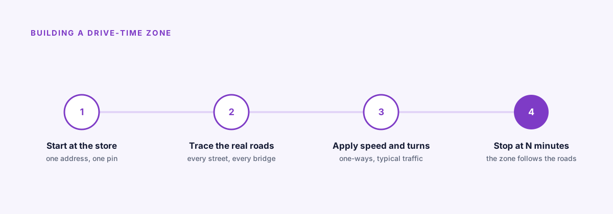
How the shape gets built: starting from the store and following the road network outward, not a ruler.
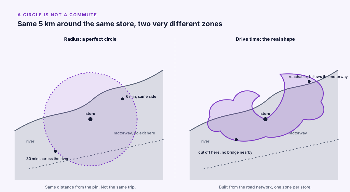
Same store, same 5 km, two completely different zones once the roads are taken into account.
That irregular shape is not an approximation of the truth. The circle is the approximation. The isochrone is closer to what a customer actually experiences when they decide whether a trip to your store is worth it, the same real-world precision discussed in our piece on local advertising at scale.
How does Map build a drive-time zone around each store?
In Arago, this zone is called a drive-time zone, and Map is the part of the product built around it. The idea is deliberately simple: one zone per store, measured in real driving time, not straight-line distance.
A few things follow from that:
- Each store gets its own shape. A store next to a motorway interchange gets a zone that reaches far along the highway. A store boxed in by a river and a one-way grid gets a tighter, oddly shaped zone, because that is the honest answer for that location.
- You can draw it yourself, directly in Map, if you know the area and want to shape the zone by hand: include the neighborhood across the bridge, exclude the industrial park nobody drives through to reach you.
- You can import it, as a GeoJSON file, if the zone already exists elsewhere, from a store locator tool, a logistics system, or any mapping software that exports standard polygons.
Once a zone exists, it plugs straight into targeting. This matters because Map does not work in isolation: it feeds the DSP. When Arago’s auction evaluates a bid request, one of the checks it runs is whether the device is inside the zone attached to that line item. A request from inside the drive-time zone around a store is treated as reachable. A request from 4 kilometers away on the wrong side of the river, inside what a circle would have called close, is not.
Why this compounds with everything else
A drive-time zone by itself already fixes the geometry problem. It compounds further once you consider how Arago structures campaigns for businesses with more than one location. Every store gets its own line item: its own budget, its own creative, and its own zone, the same structure covered in one line item per store. A retailer with 120 stores does not run one blurry national campaign with a single oversized radius guessing at everyone’s catchment. They run 120 precise ones, each shaped by the roads around that particular store.
The budget for the store near the motorway interchange, which can reasonably expect a lot of cross-town traffic, does not have to be diluted across customers who were never going to make the trip. The budget for the store squeezed between a river and a rail line goes exactly where the road network says people can actually come from.
The map looks less tidy, on purpose
It is worth saying plainly: a drive-time zone is not going to look as clean on a slide as a neat circle. It has dents, fingers, and the occasional sharp cutoff where a river or a rail line gets in the way. That untidiness is the whole point. It is the map admitting that a river is a river and a motorway is a motorway, instead of pretending every direction from a store is the same.
A circle asks “how far”. A drive-time zone asks the question customers actually answer before they get in the car: “how long will this take, from where I actually am”. Targeting the second question, instead of the first, is the difference between reaching the people who were realistically going to show up and spending a budget on people who were never going to make the trip at all. Our broader piece on geotargeting for local retail covers the other targeting decisions that sit alongside this one.
FAQ
What is the difference between drive-time targeting and radius targeting?
Radius targeting draws a plain circle of a fixed distance around a point. Drive-time targeting, built on an isochrone, traces the real road network outward from that point and stops wherever a chosen travel time runs out, so rivers, motorways and one-way streets shape the zone instead of being ignored.
Why does a radius overstate how easy a store is to reach?
A radius assumes every direction is equally crossable, at the same speed, with nothing in the way. Real catchments are cut by rivers, speeded up by motorways and complicated by one-way streets, so two points at the same straight-line distance can have very different real travel times.
Can a drive-time zone be drawn by hand?
Yes. A zone can be drawn directly on a map if you know the area, or imported as a GeoJSON file if it already exists in a store locator tool or logistics system.
Does a drive-time zone change with traffic?
Building a realistic zone typically accounts for typical traffic patterns at different times of day, since the same road can be a six-minute hop at 11 a.m. and a half-hour crawl at 6 p.m.
Does drive-time targeting work for a retailer with many stores?
Yes, and that is where it compounds. Each store gets its own zone shaped by the roads around it, rather than one national campaign guessing at everyone’s catchment with a single oversized radius.
How Arago helps
In Arago, every line item carries its own drive-time zone, drawn by hand in Map or imported as GeoJSON, measured in real driving time rather than straight-line distance. That zone plugs straight into the DSP: when the auction evaluates a bid request, it checks whether the device sits inside the zone attached to that line item before it ever bids. A brand launching in 3 cities and a retailer running 120 stores both work from the same structure, one zone, one budget and one ad per location.